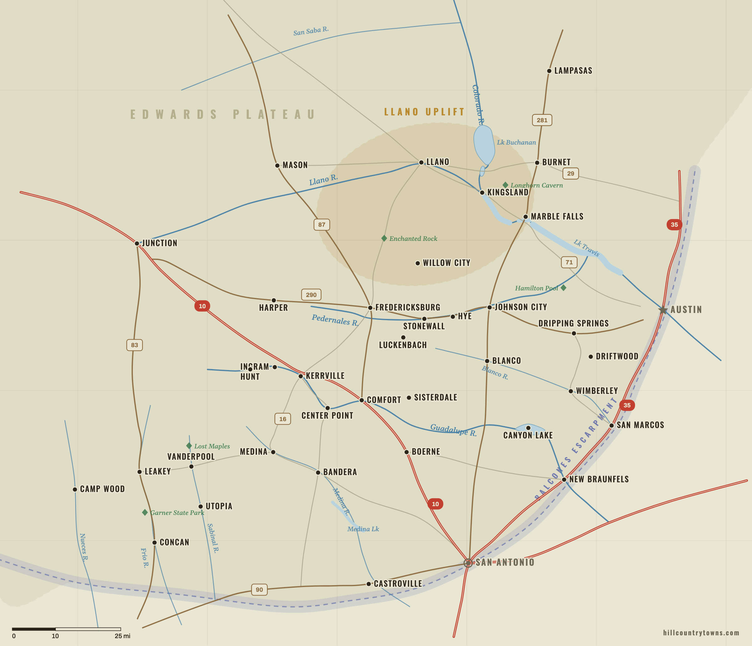
The Texas Hill Country is real, but its edge is fuzzy. It is a geographic and cultural
region rather than a single legal district, so different maps include different counties
and edge communities.
Physically, much of the Hill Country is the deeply eroded eastern side of the Edwards
Plateau. The Balcones Escarpment helps define its eastern and southern transition, while
the Llano Uplift creates a geologically distinct central mineral region around Llano,
Burnet, Marble Falls and Enchanted Rock. Culturally, the name “Hill Country” is often
used more broadly for the towns, river valleys and ranch country between Austin,
San Antonio and the western plateau.
Layers
Generalized geographic context — not an official boundary.
The shaded layers are learning aids drawn from the game’s own generalized geography,
not surveyed lines.
There is no single official Hill Country border
“Hill Country” is a vernacular regional name, not a county government or statutory
boundary. The Texas State Historical Association describes a Hill Country spanning all
or part of roughly twenty-five counties, while tourism regions, ecological maps and
local organizations use somewhat different footprints.
That is why reasonable maps disagree about edge communities. New Braunfels and
San Marcos sit along the eastern transition. Austin and San Antonio touch the region
but are usually treated differently from interior towns such as Fredericksburg,
Kerrville and Blanco. A map can be useful without pretending that one line is the
only correct answer.
The physical geography underneath the name
The Hill Country owes its shape to geology and erosion. Texas Parks and Wildlife
describes the eastern portion of the Edwards Plateau as deeply eroded country cut by
fast-moving streams, steep-sided canyons and springs. The Balcones Escarpment marks a
major break toward lower country on the east and south.
The Llano Uplift complicates the picture in the center and north. Around Llano and
Burnet counties, much older crystalline rocks are exposed inside the surrounding
limestone country. That is why the landscapes around Llano, Enchanted Rock and
Granite Mountain can look and feel different from the classic limestone-and-juniper
Hill Country farther south.
These labels are for map-learning orientation, not official jurisdictional boundaries.
Hill Country boundary questions
Is the Texas Hill Country the same as the Edwards Plateau?
Not exactly. The Hill Country is commonly associated with the eastern, more deeply
eroded portion of the Edwards Plateau, but “Hill Country” is also a cultural regional
name whose practical use does not match one geological polygon perfectly.
What is the eastern edge of the Texas Hill Country?
The Balcones Escarpment and related canyonlands help define the physical transition
toward lower country on the east and south. Cities along the Austin–San Antonio
corridor can sit on or near that transition.
Is New Braunfels in the Hill Country?
New Braunfels is commonly treated as a southeastern-edge Hill Country community.
Its position near the Balcones Escarpment and the Comal–Guadalupe river system makes
it a transition town rather than a deep-interior Hill Country town.
What are the best anchor towns for learning the Hill Country map?