What county is Bandera in?
Bandera is the county seat of Bandera County.
Bandera County · Medina River · Western-southern Hill Country
Bandera is the county seat of Bandera County on a cypress-lined bend of the Medina River, about 50 miles northwest of San Antonio. On the Hill Country map, it sits west of Boerne and south of Kerrville, between the San Antonio side of the region and the rougher river-and-ranch country farther west.
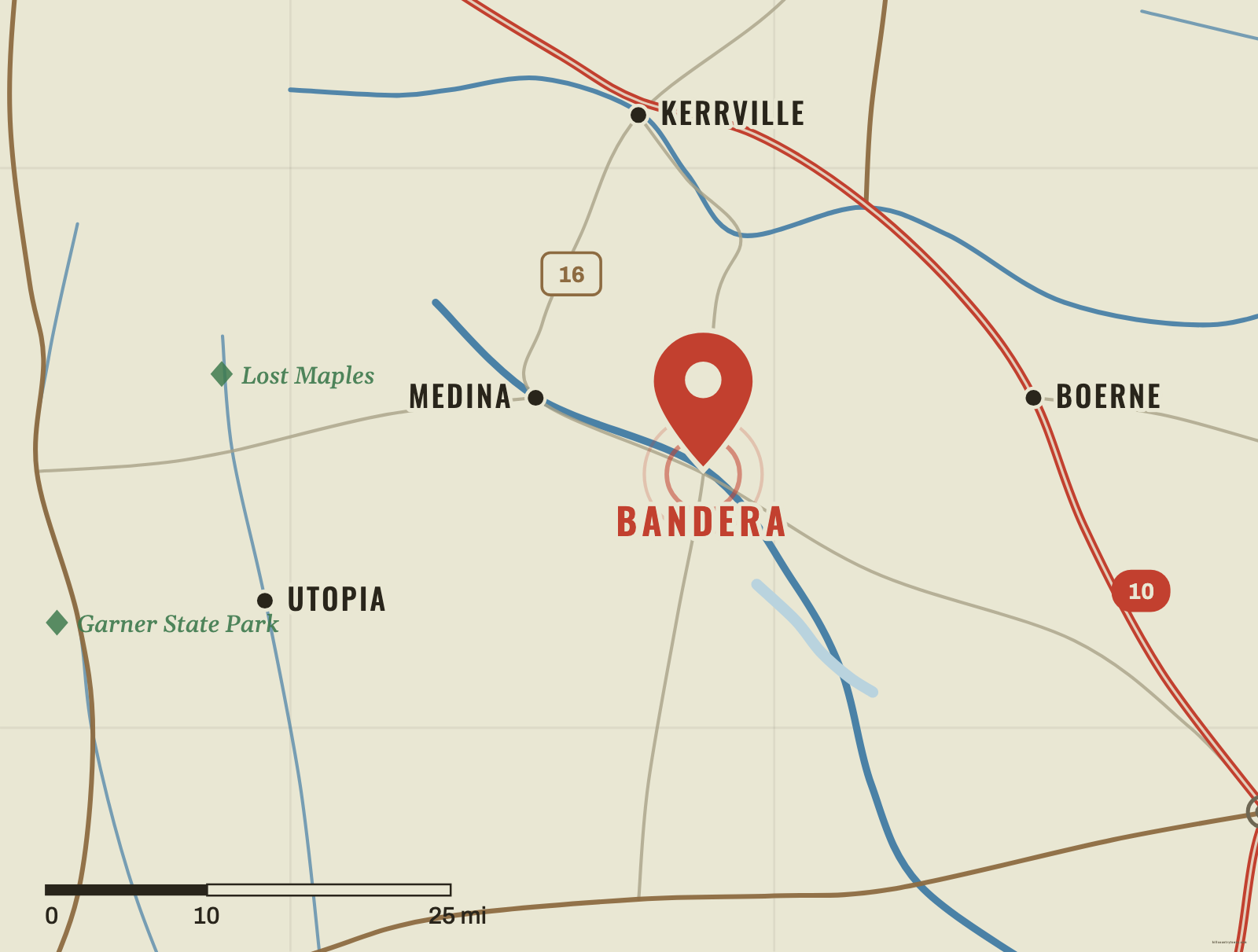
Bandera sits in the southwestern half of the Hill Country, on the Medina River. If Boerne is your anchor, move west. If Kerrville is your anchor, move mostly south. The town is close enough to San Antonio to have long served travelers coming into the region, but its geography already feels more like western Hill Country: narrower river valleys, ranch country and fewer large towns.
The Medina River is the strongest clue. Bandera occupies a bend in the river, and the cypress-lined waterway shaped the town from the beginning. Learn the river, not just State Highway 16, and Bandera becomes much easier to place.
The first permanent settlement story is tied directly to the Medina River. In 1853, John James, Charles DeMontel and John Herndon formed a partnership to establish a town and a water-powered lumber mill. Cypress growing along the river could be cut into shingles and other building material.
The founders recruited immigrant workers from Upper Silesia, and Polish families arrived in 1855. That history still distinguishes Bandera from many neighboring Hill Country towns. The community was designated the county seat when Bandera County was organized in 1856.
Bandera’s famous cowboy reputation is not the town’s origin story. It came after the Civil War, when Bandera became a staging point for cattle drives moving north along the Western Trail. Ranchers gathered cattle, outfitters supplied crews and local young men worked as cowboys and trail hands.
In the twentieth century, dude ranches, rodeos and river recreation kept that western identity alive after the great cattle-drive era ended. The useful geography lesson is that Bandera sits exactly where those stories overlap: a river settlement connected to San Antonio, but pointed west toward ranch country.
Bandera and Bandera County take their name from Bandera Pass north of town. The pass had long served as a route through the surrounding country. That gives you one more mental map cue: Bandera is not simply a dot beside San Antonio—it belongs to a north–south corridor through the Medina River country.
Why this town formed here
Schematic · not to scale
One geographic sequence explains the town: the cypress-lined Medina River drew the 1853 mill, the mill drew the Polish settlers, and after the Civil War the same spot became a staging town for cattle drives heading north.
Find the Medina
Start west of Boerne and south of Kerrville. Use the Medina River country as your clue.
Tap or click the map to drop your pin.
Bandera’s neighbors span the Medina valley and the I-10 corridor.
Approx. straight-line distances, measured from the game's coordinates — not driving distances.
Bandera is the county seat of Bandera County.
The Medina River runs through Bandera. The town developed on a cypress-lined bend of the river.
Bandera is west of Boerne and south of Kerrville, in the southwestern half of the Texas Hill Country.
After the Civil War, Bandera became a staging area for cattle drives moving north along the Western Trail. Ranching, rodeos and later dude ranches reinforced that identity.