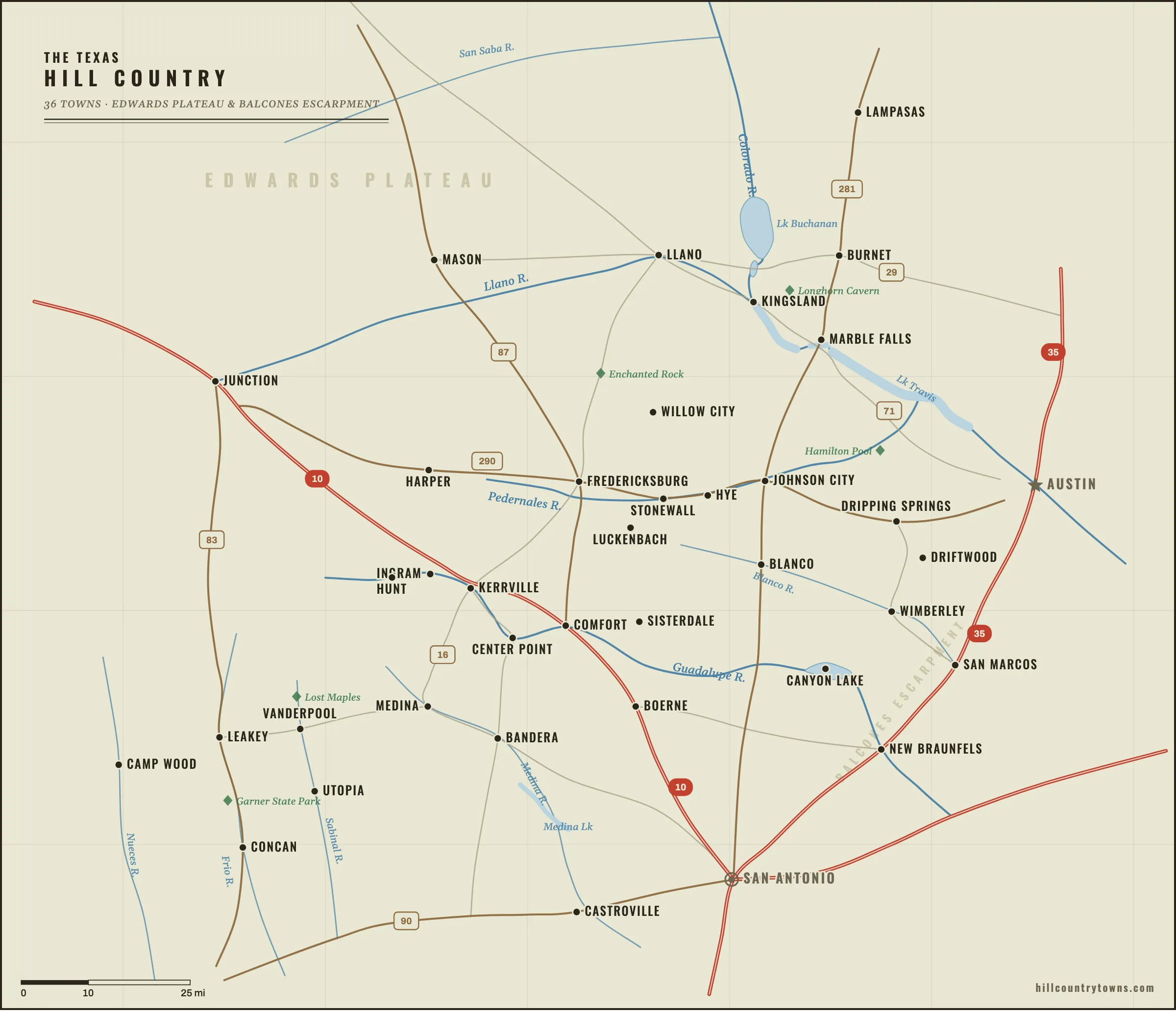
The Texas Hill Country is not one city or one neat boundary. It is a web of river towns,
German settlements, ranch communities, highway crossroads and tiny places that barely
interrupt the road. Hill Country Towns maps 36 of them—from Fredericksburg and Kerrville
to Luckenbach, Wimberley, New Braunfels and much smaller communities that are easy to
miss unless you know where to look.
Use the map to study the region, open a town guide, or jump back into the game and
see how many places you can pin without labels.
Every town in the game now has its own map guide. Use the game categories below for
difficulty, or switch to river relationships when you want to learn how the region actually fits together.
Texas Hill Country map with 36 towns. Use the interactive game to test yourself without labels, or open a town guide for a closer look.Map page & downloads
Free to share for editorial or educational use with a link to HillCountryTowns.com.
The fastest way to learn 36 towns is to stop memorizing 36 separate dots. Learn a few
geographic clusters, then use the anchor towns to place the smaller communities around them.
Fredericksburg is the strongest anchor in the middle of the map. Luckenbach sits southeast of it; Stonewall and Hye continue east toward Johnson City; Willow City lies north. Once Fredericksburg is fixed, this whole section becomes easier.
In the south-central and western Hill Country, rivers do much of the organizing. Kerrville, Ingram and Hunt follow the Guadalupe corridor; Boerne belongs to Cibolo Creek; Bandera sits on the Medina River.
The Colorado River, Highland Lakes and Llano River organize the northern part of the game. Marble Falls sits on the Colorado; Llano sits upstream and west on the Llano River; Burnet anchors the country north of Marble Falls.
The eastern edge is where the uplands drop toward the Austin–San Antonio corridor. Wimberley sits west of San Marcos; New Braunfels lies farther south where the Comal meets the Guadalupe.
The towns get farther apart toward the west and southwest. The Frio and Nueces river country is less about interstate corridors and more about canyons, river valleys and a handful of small communities.
Learning clusters, not legal subregions — the groupings are for building a mental map.
Learn the towns by water
Rivers organize the Hill Country better than roads do. Group the towns by the water that
connects them and the map starts to make physical sense — upstream and downstream instead of
a scatter of dots.
Ingram and Hunt sit upstream of Kerrville; Center Point and Comfort lie downstream; the river reaches Canyon Lake and New Braunfels far to the southeast.
The Llano River forms at Junction, runs east through Mason County and Llano, and reaches Lake LBJ at Kingsland — the Highland Lakes country of Marble Falls and Burnet.
The Medina River assembles near Medina, flows past Bandera, and reaches the Castroville valley downstream.
Generalized river relationships for learning — not a hydrologic survey.
Find the weird stuff between the towns
The map gets stranger once you leave the town squares. A rusty pasture “Loch Ness Monster,”
a fake Old West town, a 1918 bat tower, giant fiberglass cowboys and the relocated
Texas Chain Saw Massacre house all sit between these 36 towns. Go find
the weirdest roadside attractions in the Texas Hill Country.
What counts as the Texas Hill Country?
The Texas Hill Country is a cultural and geographic region rather than a single legal
boundary. Much of its rugged limestone terrain belongs to the Edwards Plateau, while
its eastern edge drops toward the Balcones Escarpment and the Austin–San Antonio
corridor. Different maps draw the boundary differently, which is why some edge
communities—especially places such as New Braunfels and San Marcos—can appear
inside one Hill Country definition and outside another.
This map is designed for learning the towns people commonly associate with the Hill
Country rather than enforcing one official border. The result is intentionally
practical: if a place belongs in the mental map Texans use when they talk about the
Hill Country, it can belong in the game. For the longer answer — the Edwards Plateau,
the Balcones Escarpment and why reasonable maps disagree — see
Where is the Texas Hill Country?
Learn the region by relationships
The fastest way to learn the Hill Country is not to memorize 36 isolated dots.
Learn the relationships. Kerrville sits on the Guadalupe west of Fredericksburg.
Luckenbach is tucked southeast of Fredericksburg. Wimberley lies west of San Marcos
near the Blanco River and Cypress Creek. New Braunfels marks the southeastern edge
of the region where the Comal meets the Guadalupe. Once a few anchor towns lock into
place, the smaller communities become much easier to find.